Welcome to GravimeTerra
GravimeTerra is a free online web platform designed to enhance the precision and efficiency of gravity field survey measurement reductions. It serves as a tool for geophysicists, researchers, and survey professionals, simplifying complex data analysis with a comprehensive suite of advanced tools.
Dive Into Your Survey Data with GravimeTerra
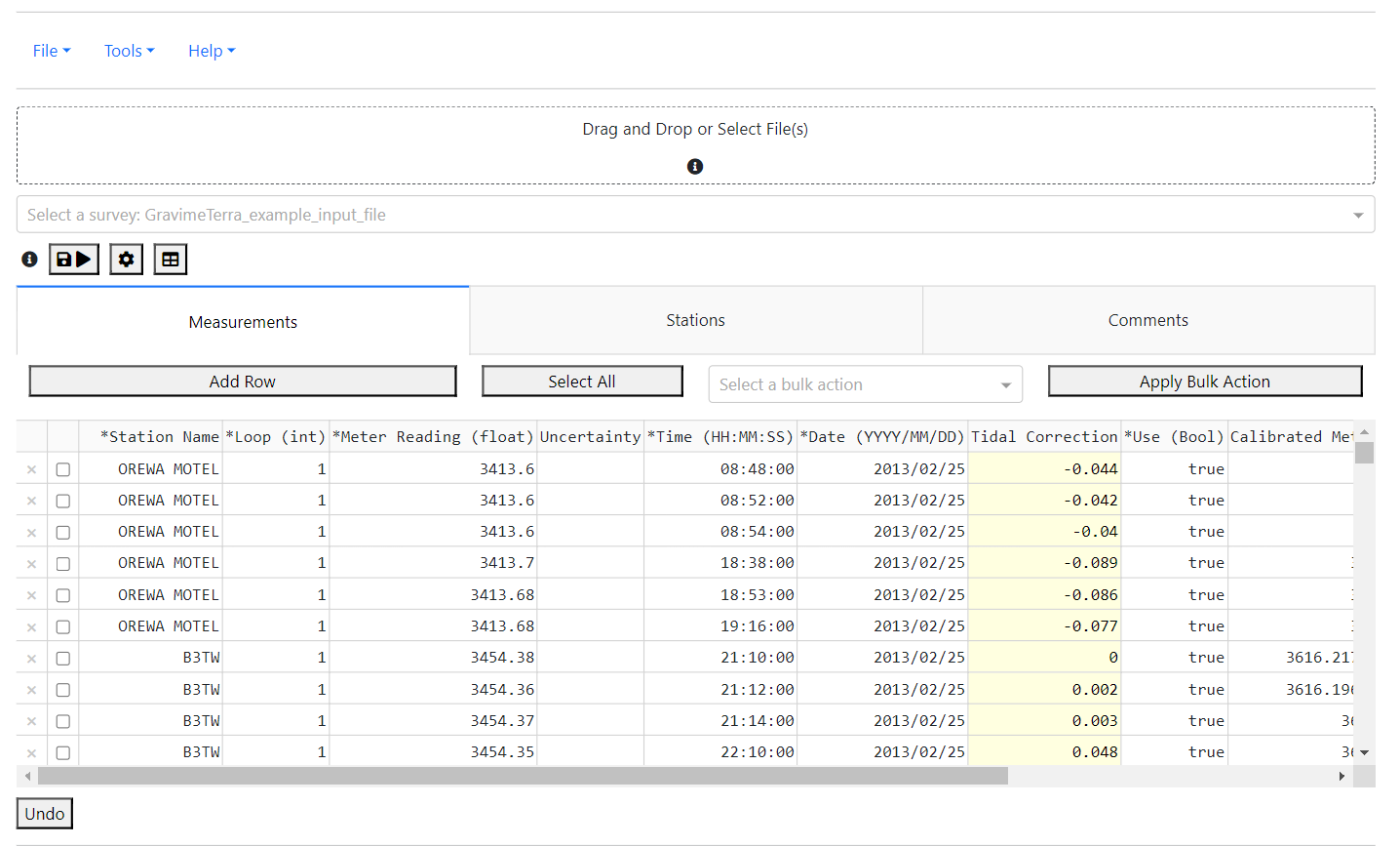
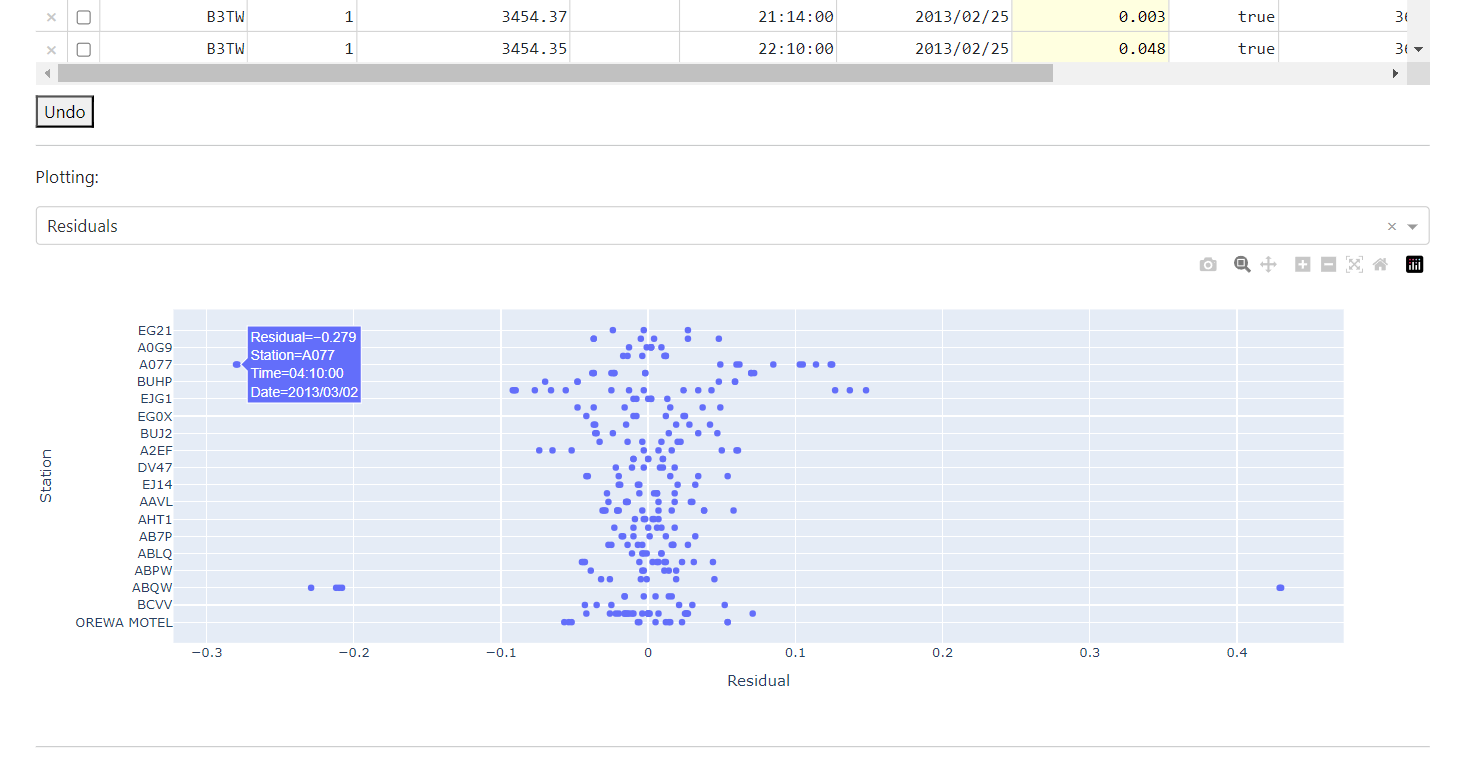

Explore interactive visualizations and gain valuable insights into your survey data. GravimeTerra transforms complex datasets into clear, actionable information.
Comprehensive Processing Capabilities
- Least Squares Adjustment: Implements least squares to reduce the field survey relative gravity measurements to final gravity values - correcting for gravimeter drift, scale factors and bias/steps in the observation, where adequate constraints are available in the input datasets.
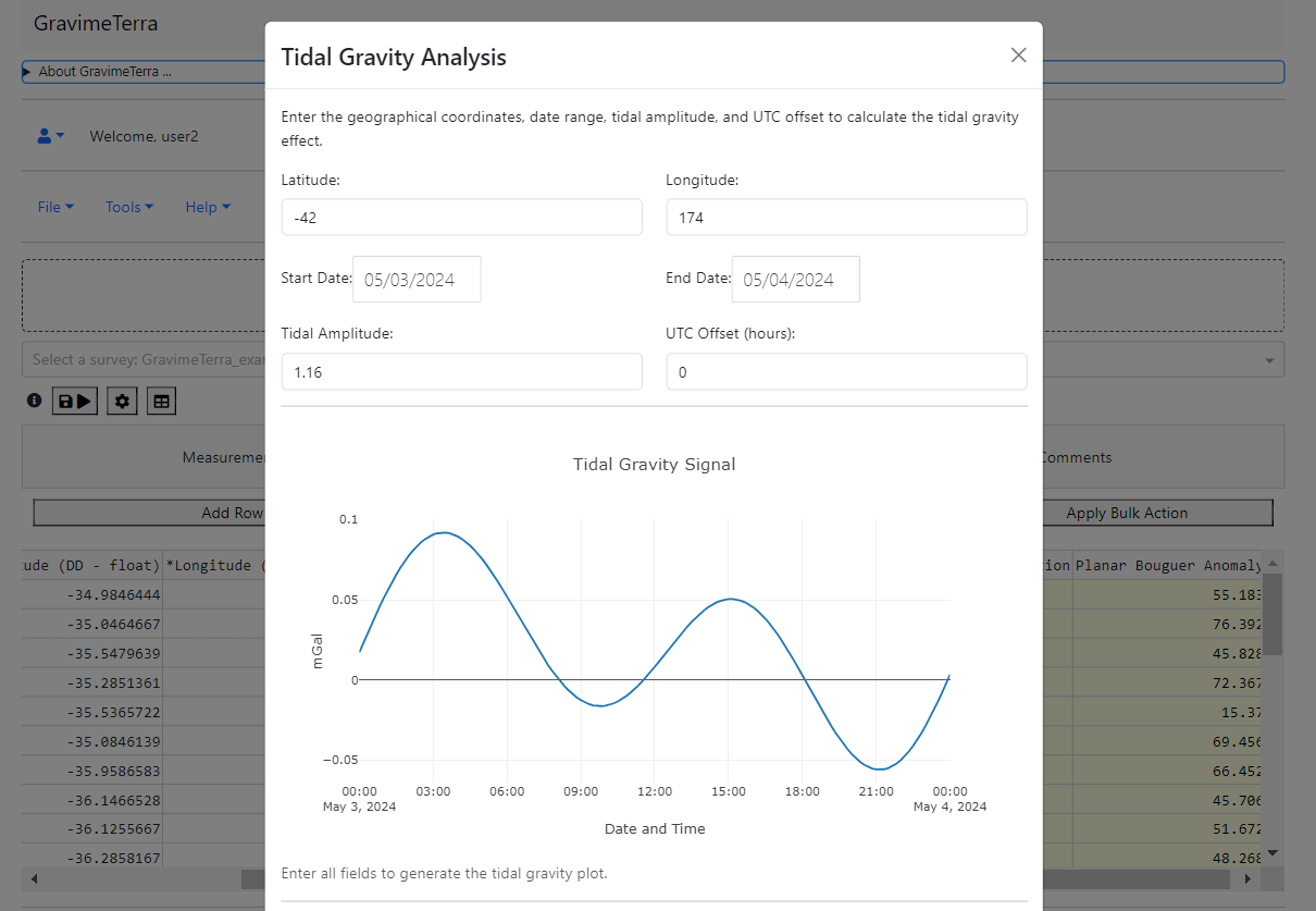
- Tidal Corrections: Adjusts for gravitational effects of lunar and solar positions
- Drift Correction: Compensates for bias and drift within survey loops, to accomodate tares.
- Automated Outlier Removal: Automatically detects and removes data anomalies to maintain data quality, with user set rejection thresholds.
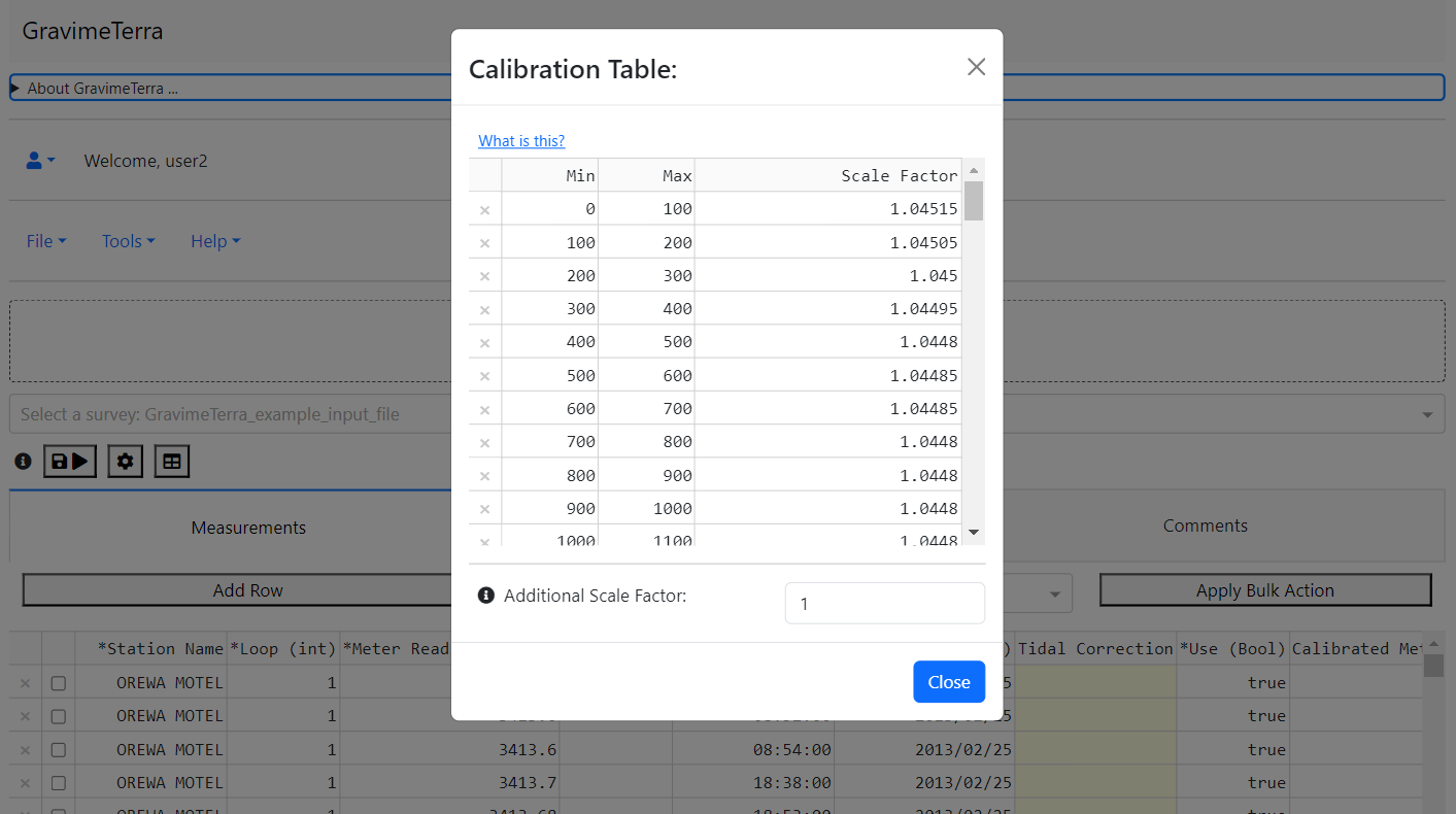
- Scale Factor Calibration: Precisely adjusts gravimeter readings through multi-point calibration where there are two or more constraint stations.
- Datum Connection: Standardizes data by linking to a gravity datum, ensuring consistent analysis.
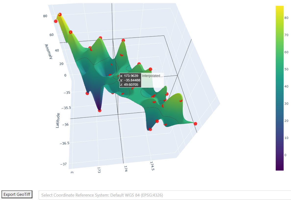
- Gravity Anomaly Reductions: Applies comprehensive corrections including free air, terrain, and Bouguer for detailed reductions and 3D visualisations.
- Spatial Analysis and DownStream Processing: Offers detailed spatial analysis outputs in gridded raster, xlsx, and JSON formats for downstream data interpretation.
- Multiple Survey File Processing: Multiple survey files can be processed in the same session, to ensure consistency accross processing parameters. Taking things even further...
- Union Solve: This feature integrates all survey data into a single least squares adjustment. It calibrates each dataset using specific calibration tables and scale factors tailored for each gravimeter involved. This method is particularly effective for merging disparate datasets collected from large-scale surveys that utilize multiple gravimeters, ultimately producing a unified set of final gravity values.
Supported File Types
Learn more about the different file types supported by GravimeTerra for import and export of survey data:
- *.json: Import/Export option for projects consisting of multiple surveys. Our native data format.
- *.xlsx: Import/Export option for easy editing. See "File - Template import file *.xlsx"
- *.TXT: CG-5 data dump text file.
- *.dat: CG-6 data dump file.
Get Started Now - Accounts are Free!
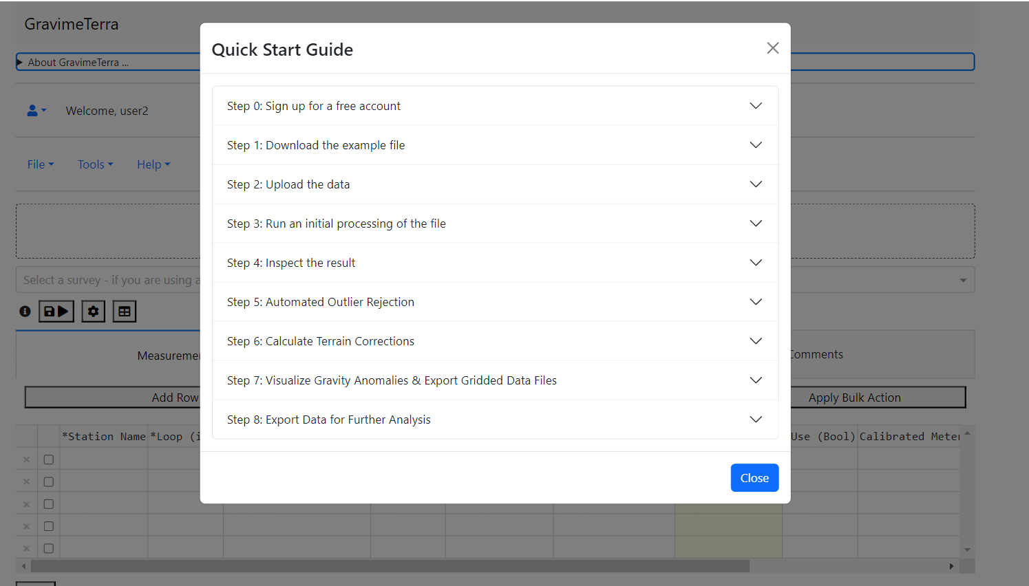
Sign up today and begin using GravimeTerra immediately for free! Download our Template Import File or explore our Quick Start Help Guide with a sample gravity survey file to see GravimeTerra in action.
Designed for Professionals and Academics
Whether you are a seasoned professional or new to the field of geophysics, GravimeTerra is tailored to meet your needs. Our platform facilitates operational data processing, academic research, and educational purposes, making complex data analysis accessible to all.
Special Requests and Inquiries
For users with specialized requirements such as air-gapped environments or those needing enhanced data processing capabilities, GravimeTerra offers custom solutions. Please contact us at gravimeterra@gmail.com to discuss how we can support your specific needs.
Terms, Conditions, and Data Privacy
By using GravimeTerra, you agree to our Terms and Conditions.
By using GravimeTerra, you agree to the following terms and conditions:
- License: GravimeTerra grants you a non-exclusive, non-transferable license to access and use the platform for gravity field survey analysis, subject to these terms.
- User Account: Each user account is allocated a daily processing balance, allowing the processing of a set number of stations as defined by the administrator. This balance resets daily.
- Data Privacy: GravimeTerra allows users to save their projects along with their survey data on the platform for future retrieval. While we make a best effort to protect this data, please note that we cannot guarantee its absolute security. The safekeeping of your data ultimately rests with you, the user. It is your choice to protect your data as needed. No user data is stored on the platform outside of saved projects. GravimeTerra does not claim ownership of the data processed or stored through the software; all results and data remain the sole property of the user. Additionally, GravimeTerra will not use the data stored or passing through the software for any purpose other than the intended analysis and storage within your projects.
- Acceptable Use: The tool is intended for operational data processing, academic research, and educational purposes in geophysics and earth sciences. Any misuse or unauthorized access is strictly prohibited.
- Intellectual Property: All intellectual property rights in GravimeTerra and its content, including but not limited to software, documentation, visual designs, and interfaces, are owned by GravimeTerra or its licensors.
- Limitation of Liability: GravimeTerra will not be liable for any direct, indirect, incidental, or consequential damages arising out of the use or inability to use the platform.
- Amendments: GravimeTerra reserves the right to modify these terms and conditions at any time. Your continued use of the platform constitutes agreement to any modifications.
- Software for Offline Use: GravimeTerra recognizes the unique requirements of users who operate in secure or air-gapped environments. The platform is available for use in an offline mode for such scenarios. Interested parties should contact us for more information on licensing, installation, and support for offline use by emailing us at gravimeterra@gmail.com.
- Extended Data Processing Limits: Users requiring the ability to process quantities of data beyond the daily balance allocated per user account may be eligible for enhanced processing capabilities. GravimeTerra offers options for increased data processing limits through bespoke arrangements tailored to your project's needs. For more information and to discuss the best solution for your data processing requirements, please reach out to gravimeterra@gmail.com.
Visualize Your Data with GravimeTerra
Explore interactive visualizations and gain valuable insights into your survey data. GravimeTerra efficiently transforms survey datasets into clear, actionable information.